UML Researchers on the Science Behind the Rise of Extreme Weather Events
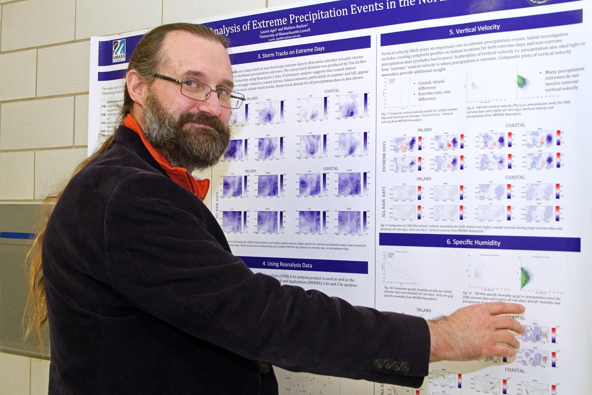
Prof. Mathew Barlow presents his research on extreme precipitation.
10/06/2023
By Brooke Coupal
Last December, a historic blizzard blanketed Buffalo, New York, with more than four feet of snow. Three months prior, devastating 150 mph winds ripped through Florida as a Category 4 hurricane made landfall. Even as these events wreaked havoc, severe drought and intense heat waves also plagued the western and central parts of the country. More recently, Hurricane Dora produced hot, strong winds that were the biggest contributing factor to the devastating spread of wildfires on the island of Maui in Hawaii.
In the past five years, the United States has experienced 90 major weather disasters, resulting in nearly 1,800 deaths and more than $600 billion in damage, according to the National Oceanic and Atmospheric Administration. This averages out to 18 extreme weather events each year—a stark difference from the 1980s, when the country averaged three such disasters yearly.
“It’s not a matter of if we’ll get an extreme weather event. It’s really a matter of when,” says Jeffrey Basara, the newly named chair of the Department of Environmental, Earth and Atmospheric Sciences (EEAS).
Natural fluctuations in the climate system impact the frequency and intensity of extreme weather events. However, in recent decades, human-induced climate change has played a major role, says EEAS Prof. Juliette Rooney-Varga, director of the Climate Change Initiative.
“Fossil fuel emissions are creating a warmer planet, which in turn is causing weather events to become more extreme,” she says.
As weather events such as heat waves and rainstorms intensify, there is a growing threat of natural disasters, ranging from floods and landslides to wildfires and tsunamis.
“Researching extreme weather is extremely important, because it gives people a deeper understanding of these events, allowing them to better prepare for possible disasters,” Basara says.
“It’s not a matter of if we’ll get an extreme weather event. It’s really a matter of when.” -Jeffrey Basara, Environmental, Earth and Atmospheric Sciences chairWith this in mind, we asked our experts to share the science behind some of the most prevalent types of extreme weather.
Droughts
Have you ever walked into the rain and said, “Wow, we needed this?” This statement holds an even stronger meaning for people dealing with drought.
Droughts are the result of a lack of precipitation over a prolonged period, but what causes that dry weather? EEAS Asst. Prof. Christopher Skinner and a team of researchers discovered that the El Niño-Southern Oscillation (ENSO), a recurring pattern of changes in water temperature in the Pacific Ocean, is a driving factor, particularly for droughts that occur in multiple regions at the same time.
Their finding, which was published in the journal “Nature Climate Change,” makes it easier for scientists to forecast droughts because they can already predict the El Niño-Southern Oscillation with some regularity.
“Generally, several months in advance, you have an idea of whether you’re going to have a particular pattern of sea temperatures in the Pacific Ocean,” Skinner says. “So, if we know that a certain phase of ENSO is coming, we have a better sense of whether or not there’s going to be a concurrent drought in the subsequent months.”
This predictability is crucial for sectors like agriculture, which is often negatively affected by drought. It allows farmers to get ready in advance for the dry conditions that could damage their crops.
Croplands are especially susceptible to flash droughts, which are droughts that develop rapidly, Basara says. The chance of cropland experiencing a flash drought in North America is expected to increase to 49% by the end of the century, compared with 32% in 2015, according to a paper co-authored by Basara and recently published in the journal “Communications Earth & Environment.” To lessen this risk, Basara says more action needs to be taken to slow global warming, as this is a cause of increased flash droughts.

Asst. Prof. Christopher Skinner takes in nature's beauty on Wantastiquit Mountain.
The warming climate has also contributed to more intense heat waves, studies have shown. The extreme heat and dry weather conditions create a breeding ground for wildfires.
In June 2023, more than 400 fires sparked throughout Canada following an unusual spell of hot and dry weather. Smoke from the wildfires traveled down into the eastern United States, causing poor air quality and reduced visibility.
“Vegetation can become very dry and combustible when there hasn’t been much precipitation and when warm temperatures evaporate the moisture from the soil,”
Skinner says. “Most wildfires in the U.S. are sparked unintentionally by humans, such as by campfires and cigarettes, but they can also be ignited by lightning.”
While dry weather conditions have been well-researched in the western and central United States, Skinner says droughts in the Northeast are understudied because historically, they happen less frequently. To help change that, Skinner teamed up with EEAS Prof. Mathew Barlow to further investigate the causes of droughts and heat waves in the local region. The research is funded by a $478,000 grant from the National Oceanic and Atmospheric Administration.
“We hope to answer some important questions, such as how well can we predict droughts and heat waves, and how much more often will we get this kind of weather in the future?” Barlow says.
Heavy Precipitation
Since the 1800s, the Earth has warmed by about 1.1 degrees Celsius. This not only plays a factor in drought, but it also influences precipitation.
“A warmer atmosphere can hold more water, so when there’s a lot of water around, you’re increasing the potential for heavy precipitation,” Barlow says.
The water cycle will only continue to intensify as the planet gets warmer, adding to the urgency of mitigating climate change.
“Reducing greenhouse emissions will reduce impacts,” says Barlow, who co-authored the latest Intergovernmental Panel on Climate Change report. “Every fraction of a degree matters.”
In the Greater Boston area, residents can expect to see more rain than snow, as global warming is likely to increase rainfall and decrease snowfall, according to the report “Climate Change Impacts and Projections for the Greater Boston Area,” for which Barlow led the Storms, Precipitation, Flooding and Groundwater section. His research on extreme precipitation in the Northeast was funded by a $454,000 National Science Foundation grant.
The West has experienced its share of extreme precipitation in recent years. In October 2021, California’s Bay Area received historic rainfall, with more than 11 inches of precipitation recorded in some towns. Two months later, the state’s Sierra Nevada mountain range recorded nearly 18 feet of snow. These extreme weather events resulted from atmospheric rivers, or long, narrow bands of water vapor that travel in the atmosphere.
“When atmospheric rivers hit a mountain range, all the water that was inside the river falls onto the surface. It happens a lot in California because the state has a lot of topography,” says Skinner, who researched the weather phenomenon as part of a $225,000 National Science Foundation grant.
Since more water vapor is in the atmosphere due to the warming planet, Skinner says these atmospheric rivers are resulting in heavier precipitation. To better understand how this impacts people and the ecosystem, he has been studying atmospheric rivers from thousands of years ago.
“People are always asking, ‘Why do you care about the climate from thousands of years ago?’ But really, it helps us contextualize the changes that we’re seeing with the climate right now,” he says. “We can get a sense of what we can expect to see in the future.”
Heavy rainfall in any part of the country poses the risk of severe flooding, which can be especially detrimental for cities, as they typically are dominated by surfaces like pavement that do not absorb water. EEAS Asst. Prof. Joy Winbourne is researching how trees in cities can be used to help mitigate stormwater runoff and other negative effects of climate change.
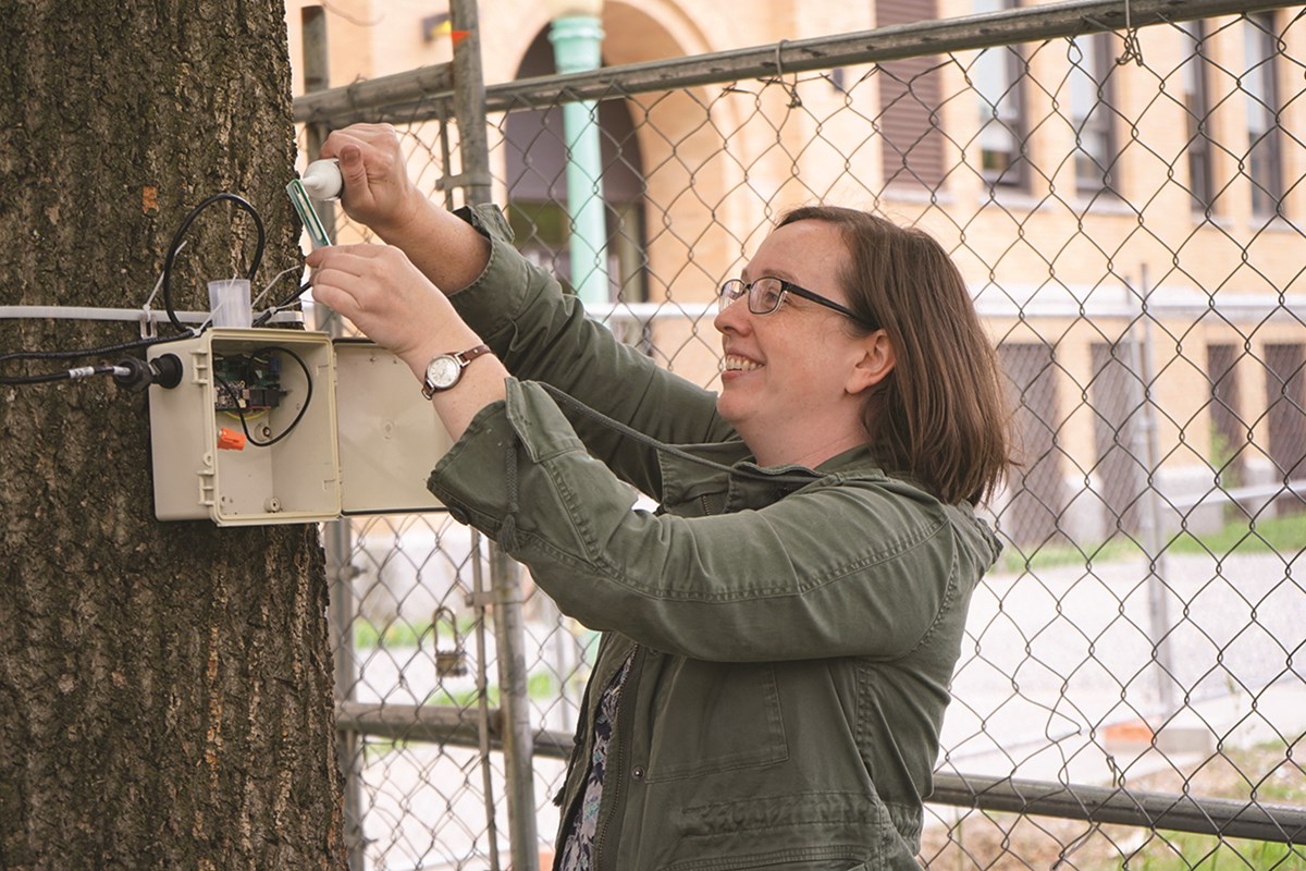
Asst. Prof. Joy Winbourne deploys a sap flow sensor to monitor the tree's response to extreme weather events.
Hurricanes
As Hurricane Ian churned in the Caribbean Sea in September 2022, forecasters predicted that the powerful storm would travel along the Florida coastline before making landfall in Florida’s Panhandle. But the Category 4 hurricane had other plans.
“Instead of the hurricane going up the Panhandle, it ended up going into Central Florida,” EEAS Prof. Frank Colby says.
The inaccurate forecast proved problematic for residents, some of whom, Colby says, had fled the Panhandle and gone to Central Florida in search of safety. Ultimately, Hurricane Ian resulted in 152 deaths and more than $100 billion worth of damage.
“As we’re seeing more intense storms, it makes it even more crucial to be able to forecast them accurately,” says Colby, who is working with Barlow and Andrew Penny of the National Hurricane Center to help improve hurricane forecasts.
Forecasters rely on dozens of computer models to predict the track and intensity of hurricanes. By comparing models, the forecasters can typically get a good idea of where the hurricane is headed.
“If there is one model going out into left field, the forecasters can decide to discard that one and go with the consensus from the others,” Colby says.
But occasionally, the majority of the models will agree on an inaccurate track forecast, as was the case with Hurricane Ian.
“It’s extraordinary when that happens, because the track errors suddenly double, and the National Hurricane Center is left without any reliable guidance,” Colby says.
Since the computer models all use different mathematical equations to forecast hurricanes, Colby and his team believe the atmosphere is to blame for significant track changes.
Using ensembles, which produce a set of forecasts based on a range of future weather possibilities, the researchers discovered that for Hurricane Ian, a small wave in the jet stream moved its track to Central Florida.
The researchers are now examining additional hurricanes to find other atmospheric features that impacted their paths in drastic ways. One such storm was Hurricane Florence, which, in September 2018, took an unexpected 90-degree turn toward the East Coast of the U.S. after initial models showed it moving north in the middle of the Atlantic Ocean.
“By figuring out which features forecasters need to be worried about, we can help improve hurricane track forecasting,” Colby says. “Accurate forecasting is critical for storm preparation and safety.”
Storm Surge
When a hurricane or nor’easter barrels toward the coast, a storm surge is often imminent.
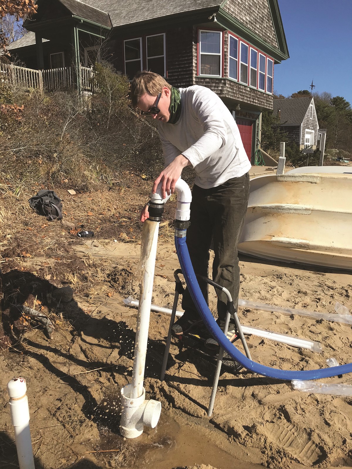
Using jets of water at high pressure, Asst. Prof. James Heiss drills a sampling well into a beach.
Funded by a $784,000 National Science Foundation grant, Heiss is studying how increased storm surges and other effects of coastal storms impact beach aquifers — the underground layer of rocks, sand and gravel that holds water.
Fresh groundwater discharged into the ocean can be harmful to marine life because it carries pollutants from human activities. The pollution can cause toxic algal blooms, which can then lead to mass die-offs of fish and a loss of biodiversity. The mixing of groundwater and saltwater in beach aquifers, however, can help prevent the toxins from reaching the ocean.
“The mixing zone in the beach aquifer is beneficial, because it sets off chemical reactions that remove contaminants in groundwater that would otherwise discharge into the ocean via groundwater pathways,” Heiss says.
At the U.S. Army Corps of Engineers Field Research Facility in Duck, North Carolina, Heiss and his research team installed wells equipped with sensors that monitor the groundwater in aquifers when coastal storms hit. He says the research will reveal how more frequent and intense storm surges impact the groundwater flow and mixing patterns between seawater and fresh water in beach aquifers.
“Beach aquifers are important in helping to promote healthy coastal ecosystems,” he says.
Heiss is also researching how heightened storm surges and other extreme weather events like drought may cause saltwater to travel farther inland through aquifers.
“The intrusion of saltwater is a major problem in many coastal communities and large cities that rely on groundwater as a source of drinking water,” he says.
Heiss and his team are analyzing saltwater intrusion and chemical exchanges across the interfaces of aquifers and estuaries (where freshwater rivers or streams meet the ocean) to better understand the impact of extreme weather on groundwater resources. The research is being funded by a $680,000 National Science Foundation CAREER award.
Knowledge obtained from the projects could help improve the management of the ocean and fresh groundwater, Heiss says. For instance, it could guide where groundwater pumping wells should be placed and help coastal managers better predict when an algal bloom may occur.
Students play an integral part in the research efforts of UML faculty, including Heiss, who enlisted computer science and engineering majors to develop the sensors used for groundwater monitoring in North Carolina. He and Skinner also work closely with Ph.D. students in the new Earth System Science program.
“We need bright minds to help tackle these challenging projects,” Heiss says. “That’s where our students come in.”
To help grow weather research among faculty and students, Skinner is spearheading the launch of a new weather station on South Campus. Solar panels will power the station, which will include instruments capable of collecting data on temperature, wind and other weather conditions.
“The station will give students the chance to gain valuable hands-on experience taking measurements,” Skinner says.
Basara says that research opportunities are essential for helping students grow into professionals.
“We are training our students to become the next generation of scientists that will be needed to solve complex issues,” he says, “including those that involve extreme weather.”